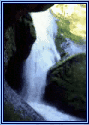


~~* The Singing Falls Stream Restoration Project *~~
 ϕ
ϕ
~~* Project Treatment Site Index *~~
This is one of my all time favorite sections of the stream restoration web site. If you are a “visual” type of person this is a good place to catch the flavor of what stream restoration is all about.
Our habitat restoration project has been divided up onto discreet location sites (treatment sites) for the purpose of the implementation phase. Initially this consisted of 43 positions along Joe Hall and Alexandra Creeks. When the main dispersal of large wood and boulders was about to take place the project team lead reduced the site numbers to 33. This was done to facilitate the combining of certain areas into a single zone. The vast majority of the large wood pieces consisted of logs that were 55 feet long and some of the site positions were of a closer proximity in distance than that.
Since the prework photography contained all 43 sites I have separated this index hyperlink map and a corresponding treatment site table into that many cells for the sake of taking full advantage of the before and after images. Keep in mind that habitat restoration is an ongoing process. It takes several years for the ecosystem to adapt to the environmental alterations that have been made.
I've created a hyperlinked image below as a means navigation via a “hot spot map“. By selecting (clicking) a position number or its corresponding green dot on the map you will be able to navigated to the page pertaining to that location in the project area. Each of the comments cells in the table beneath the “hot spot maps“ will take you to the treatment site pages also.
Navigation links are located at the bottom of each treatment site images page so you can return here.
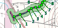 |
Click on a number or green dot to view site images and information.
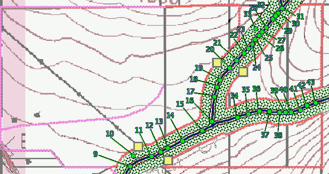 |
Click on a number or green dot on the above image to view site images and information.
~~*Treatment Site Comment and Links*~~
| site #1 Suppress blackberries, plant willow, alder and conifers |
site #2 Large wood placement, pull fence in the stream channel |
site #3 Stream bank erosion next to residence, 25' wooden bridge |
site #4 Large wood placement utilizing existing boulders for pool creation |
| site #5 Large wood or Rock Weir placement for pool creation |
site #6 Pull car bodies from active channel, large wood or rocks to agrade active channel |
site #7 Stream bank erosion, large wood or rock veins to dissipate energy |
site #8 Place large wood or rock weir for pool enhancement |
| site #9 Place large wood for pool enhancement, remove car bodies. |
site #10 Replant dead alder patch |
site #11 Livestock crossing, armor stream banks (2 x 20') |
site #12 Large wood placement along reach |
| site #13 Add large wood to existing log jam |
site #14 Large wood placement |
site #15 Large wood placement |
site #16 Boulder Fall-head cut, place grade control, large wood placement |
| site #17 Livestock crossing, armor stream banks (2 x 20') |
site #18 Large wood placement |
site #19 Supplement existing rocks to create rock weir for pool enhancement |
site #20 Livestock crossing |
| site #21 Large wood placement to enhance pools |
site #22 Barren stream reach, add large number of smaller diameter wood |
site #23 Large wood placement |
site #24 Large wood placement |
| site #25 Supplement existing rocks to create rock weir for pool enhancement |
site #26 Place smaller diameter large wood (<18"), riparian planting |
site #27 Large wood placement (Large/small) |
site #28 Large wood placement to enhance pools |
| site #29 Large wood placement to enhance pools |
site #30 Drop existing large wood into channel |
site #31 Construct small debris jam by hand |
site #32 Construct small debris jam by hand |
| site #33 Armor spring w/coarse rocks |
site #34 Large wood placement on abonded floodplain |
site
#35Reestablish overflow channel with large wood placement |
site #36 Reestablish overflow channel with large wood placement |
| site #37 Large wood placement |
site #38 Large wood placement |
site #39 Large wood placement |
site #40 Large wood placement |
| site #41 Large wood placement |
site #42 Add large wood to existing log jam |
site #43 Add large wood downstream of pool and spawning bed |
|
top


