


~~* The Singing Falls Stream Restoration Project *~~
 ϕ
ϕ
~~* Project Site Design Index *~~
This index is the repository for the preliminary design work that was done for the restoration project here at Singing Falls. These designs are a rudimentary guideline for habitat restoration. They represent a tremendous amount of work that is preparatory to this stage of development. I especially want to thank C. T. (c-dog) Baldwin, USFS Tiller District Fish Biologist and Maureen Joplin, USFS Hydrologist for "burning the mid-night oil" to get these designs out in time for the implementation phase of the project. The decision to use a helicopter for a good portion of the log distribution work came late in the process. For that reason the sites map pages and design map pages may not correlate. A little experimentation with the navigation will get you there though.
When the helicopter phase of implementation takes place it is generally "quick and dirty". It is then that the maximum amount of efficiency and skill must be applied. Care is taken to focus extreme caution for safety. The design work is done to reduce decision making during implementation. The execution of the project will have enough diversion with on the ground situations. A thorough overview of the project prior to the ground work eliminates confusion and allows all of the team members to know exactly what is going on where. Heavy equipment operators, the gigantic Chinook Helicopter operators and their team on the ground along with other team members all have a single model to work by. Each site is numbered and drawn out after careful consideration of the topography, hydrology and goals for a given geological location.
One of the most significant aspects of this phase of operations is calculating the impact of this instream work on the future of stream conditions. My neighbors down stream don't want an enormous log jam in their front yard when the next 300 year flood event takes place. The size of the logs, biological condition (state of decay), and their position in the riparian zone is all designed to maximize habitat benefits and minimize possible adverse effects dished out by the mighty hand of mother nature during flood events.
I've created a hyperlinked image below as a means navigation via a "hot spot image map". By selecting (clicking) a position number or its corresponding green dot in the riparian zone on the map you will be able to navigated to the page pertaining to that location in the project area. Some of the designs incorporate several sites along the stream and are combined. So if you are taken to the same design more than once it is for that reason. Each of the comment cells in the table below the "hot spot image maps" will take you to the site design pages also. Some of the design pages cover several of the image map sites so they will be redundant. If you mouse over a spot it will tell you what design page it will take you too.
Navigation links are located at the bottom of each design site page so you can return here easily.
Enjoy!
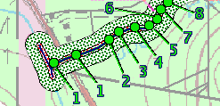 |
Click on a number or green dot to view site images and information.
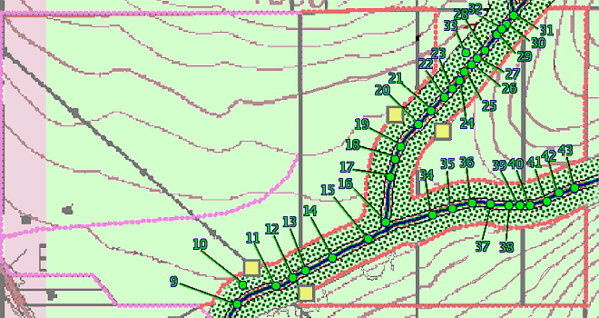 |
Click on a number or green dot on the above image to view site images and information.
~~*Treatment Site Comment and Links*~~
| design #1 Suppress blackberries, plant willow, alder and conifers |
design #2-3 Large wood placement, pull fence in the stream channel |
design #4-5 Stream bank erosion next to residence, 25' wooden bridge |
design #6-7-8 Large wood placement and boulders for pool creation |
| design #9-10 Large wood placement for pool creation |
design #11-12 Pull car bodies from active channel, large wood or rocks to agrade active channel |
design #13 Stream bank erosion, large wood or rock veins to dissipate energy |
design #14-15 Place large wood or rock weir for pool enhancement |
| design #16 Place large wood for pool enhancement, remove car bodies. |
design #17 Replant dead alder patch |
design #18 Livestock crossing, armor stream banks (2 x 20') |
design #19 Large wood placement along reach |
| design #20 Add large wood to existing log jam |
design #21 22 Large wood placement |
design #23 Large wood placement |
design #24 25 26 Boulder Fall-head cut, place grade control, large wood placement |
| design #27 28 Livestock crossing, armor stream banks (2 x 20') |
design #29 30 Large wood placement |
design #31 Supplement existing rocks to create rock weir for pool enhancement |
design #32 Livestock crossing |
| design #34 35 Large wood placement to enhance pools |
design #36 37 Barren stream reach, add large number of smaller diameter wood |
design #38 Large wood placement |
design #39 Large wood placement |
| design #40 Supplement existing rocks to create rock weir for pool enhancement |
design #41 42 Place smaller diameter large wood (<18"), riparian planting |
design #43 Large wood placement (Large/small) |
design #44 Large wood placement to enhance pools (USFS) |
| design #45 Large wood placement to enhance pools (USFS) |
design #46 Drop existing large wood into channel (USFS) |
n/a | n/a |
top


